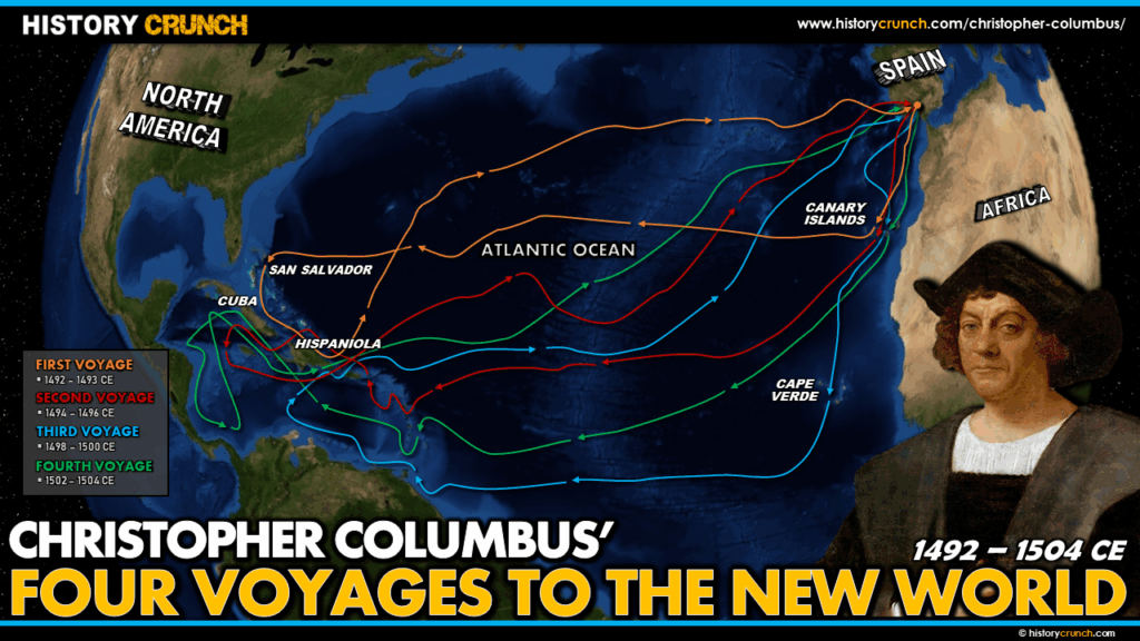
Christopher Columbus carried out four voyages to the New World between 1492 and 1503, each one building on the last and taking him further into unexplored territory. Together these four journeys transformed the history of the world, launching the Age of Exploration, beginning the Columbian Exchange and opening the Americas to European colonization. This map was created by History Crunch to help students visualize all four voyages on a single map, showing how each route differed and how Columbus’s exploration expanded with each journey. It is based on the History Crunch articles on each of Columbus’s four voyages.
Christopher Columbus All Four Voyages to the New World Map
About This Map
This map of all four of Christopher Columbus’s voyages to the New World was created by the History Crunch team to help students and teachers understand the full geographic scope of Columbus’s explorations across the Atlantic and through the Americas. It is designed as a visual learning tool to accompany our full articles on each of Columbus’s four voyages. Teachers may use it as a classroom display, a geography activity, or a discussion starter about how Columbus’s understanding of the New World evolved across his four journeys.
What This Map Shows
The map shows all four transatlantic routes that Columbus followed between 1492 and 1504, allowing students to compare the different paths and destinations on a single image.
The first voyage (1492 to 1493) shows Columbus departing Spain on August 3rd, 1492, sailing south to the Canary Islands and then west across the Atlantic using the easterly trade winds. He arrived in the northeastern Caribbean on October 12th, 1492, explored several islands including Cuba and Hispaniola, and returned to Spain on March 15th, 1493. This was the voyage that first made contact between Europe and the Caribbean and began the era of European exploration of the Americas.
The second voyage (1493 to 1496) shows a more southerly Atlantic route, departing the Canary Islands on October 13th, 1493 and arriving in the southeastern Caribbean. Columbus explored extensively through the Lesser Antilles, naming many islands still known by those names today, before reaching Puerto Rico and Hispaniola. He established the settlement of La Isabela and explored Cuba and Jamaica before returning to Spain in June 1496. This was the voyage that initiated the Columbian Exchange, as Columbus brought seeds, plants and livestock to the New World for the first time.
The third voyage (1498 to 1500) shows an even more southerly route that took Columbus to Trinidad and then to the Paria Peninsula on the coast of modern-day Venezuela, making him the first European to reach the South American mainland. The map shows his subsequent route from South America directly to Hispaniola, where growing unrest among the settlers led to his arrest and return to Spain in chains.
The fourth voyage (1502 to 1504) shows Columbus’s most extensive exploration of the Central American coastline. After stopping at Hispaniola, he sailed south to Guanaja off the coast of Honduras and then explored the coasts of Honduras, Nicaragua, Costa Rica and Panama. When his ships became too damaged to continue he was stranded on Jamaica for over a year before rescue finally arrived in June 1504. He returned to Spain in November 1504 and died in May 1506.
Taken together the four routes on the map illustrate how Columbus gradually pushed further into the Americas with each voyage while continuing to believe until the end of his life that he had reached the coast of Asia rather than an entirely new continent.
How to Use This Map in the Classroom
This map works best as a summary and review tool after students have studied Columbus’s individual voyages, allowing them to see all four routes in context on a single image. It can be used as a geography activity asking students to identify which route belongs to which voyage and describe how Columbus’s exploration expanded over time. Teachers may also use it as a discussion prompt asking students to consider the overall legacy of Columbus’s four voyages, both in terms of their significance for European exploration and their consequences for the indigenous peoples of the Americas. It pairs particularly well with the Christopher Columbus infographic and the Columbian Exchange map.
Related Articles
To learn more about the topics covered in this map, visit the following History Crunch articles:
- Christopher Columbus First Voyage
- Christopher Columbus Second Voyage
- Christopher Columbus Third Voyage
- Christopher Columbus Fourth Voyage
- Christopher Columbus
- Christopher Columbus Legacy
- Columbian Exchange
- Age of Exploration Overview
- Impacts of the Age of Exploration
- Should Christopher Columbus Be Celebrated?