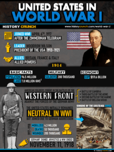
World War I was one of the most devastating conflicts in human history, fought between 1914 and 1918 across multiple fronts in Europe and the Middle East. It began following the assassination of Austrian Archduke Franz Ferdinand on June 28th, 1914 and quickly drew in the major European powers through their alliance systems, pitting the Allied Powers of France, Britain and Russia against the Central Powers of Germany, Austria-Hungary, the Ottoman Empire and Bulgaria. Understanding the geography of the war is essential to understanding why it unfolded as it did. This map was created by History Crunch to help students visualize the key geographic dimensions of World War I and is based on the History Crunch articles on World War I.
World War I Map
About This Map
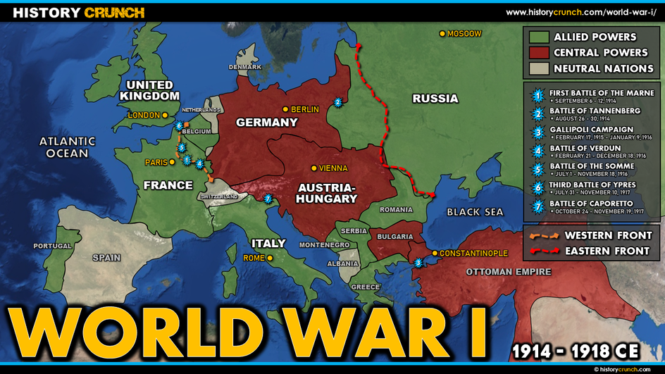
This World War I map was created by the History Crunch team to help students and teachers understand the geographic scope and key locations of the First World War. It is designed as a visual learning tool to accompany our full articles on World War I. Teachers may use it as a classroom display, a geography activity, or a discussion starter about how the geography of Europe shaped the nature and outcome of the war.
What This Map Shows
The map shows the main countries of Europe and the Middle East involved in World War I and the two opposing alliance systems that divided the continent before and during the conflict. The Triple Entente, which became the Allied Powers, consisted of France, Britain and Russia. The Triple Alliance, which became the foundation of the Central Powers, originally consisted of Germany, Austria-Hungary and Italy, though Italy switched sides in 1915 and joined the Allied Powers. The Central Powers that fought the war were Germany, Austria-Hungary, the Ottoman Empire and Bulgaria.
The map highlights the geographic context that gave rise to the war. In the decades before 1914, Europe had been divided between two competing alliance systems that created a tense and heavily armed continent. The Balkans region in southeastern Europe was a particular flashpoint, where the competing interests of Austria-Hungary, the Ottoman Empire and nationalist movements created what historians have called the Balkan Powder Keg. It was in the Balkan city of Sarajevo that Archduke Franz Ferdinand was assassinated, triggering the chain of alliance obligations that pulled the major powers into war within weeks.
The map shows the Western Front, which ran through Belgium and northeastern France and became the primary theater of the war in the west. Germany’s opening strategy was the Schlieffen Plan, which called for a rapid invasion of France through neutral Belgium in order to knock France out of the war before Russia could fully mobilize in the east. The plan ultimately failed due to French resistance, and the Western Front quickly developed into a devastating stalemate characterized by trench warfare. The front line barely moved for much of the war as both sides dug extensive trench systems and launched enormous offensives at great cost of life.
The map also shows the Eastern Front, which ran from the Baltic Sea in the north to the Black Sea in the south across large sections of Eastern Europe. Unlike the static Western Front, the Eastern Front was more dynamic with the front line regularly shifting over great distances. This was largely due to the contrast between Germany’s well-equipped and industrially advanced military and Russia’s large but poorly equipped forces. The failure of the Schlieffen Plan meant Germany was forced to fight on both fronts simultaneously, which significantly strained its resources throughout the war.
Finally the map shows the geographic extent of the Ottoman Empire’s involvement in the war through its role in the Middle Eastern theater, where British and Allied forces fought Ottoman forces in campaigns across modern-day Turkey, Iraq, Palestine and Arabia.
How to Use This Map in the Classroom
This map works well as a visual introduction to World War I before students read the full articles on its causes, major events and key countries. It can be used as a geography activity asking students to identify the Allied Powers and Central Powers and locate the Western Front and Eastern Front on the map. Teachers may also use it as a discussion prompt asking students to consider how the geographic position of Germany at the center of Europe, surrounded by France to the west and Russia to the east, shaped German military strategy and ultimately contributed to its defeat. It pairs particularly well with the WWI alliances map and the Western Front map.
Related Articles
To learn more about the topics covered in this map, visit the following History Crunch articles: