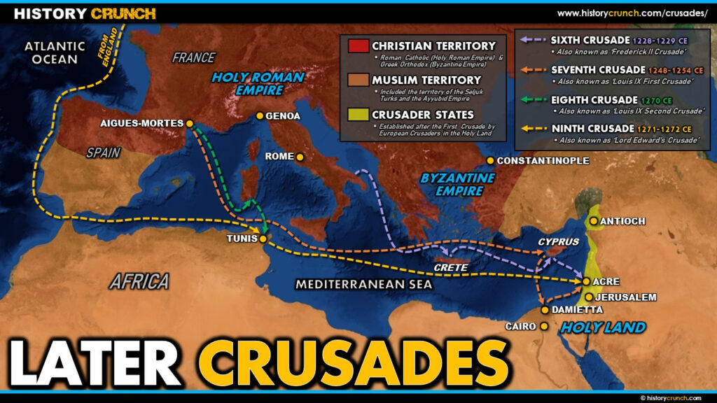
The later Crusades cover the Sixth through Ninth Crusades, which took place between 1228 and 1272 CE. By this period the crusading movement had already experienced both successes and significant failures, and European enthusiasm for the campaigns was beginning to weaken. Each of these four crusades had distinct goals, destinations and outcomes, ranging from the diplomatic success of the Sixth Crusade to the disastrous Eighth Crusade in North Africa. Together they trace the gradual decline of crusading power in the Middle East and the eventual end of the Crusader presence in the region. This map was created by History Crunch to help students visualize the geographic routes of the later Crusades and is based on the History Crunch articles on the Crusades.
Later Crusades Map (Sixth, Seventh, Eighth and Ninth Crusades)
About This Map
This Later Crusades map was created by the History Crunch team to help students and teachers understand the geographic dimensions of the four later Crusades. It is designed as a visual learning tool to accompany our full articles on the Sixth, Seventh, Eighth and Ninth Crusades. Teachers may use it as a classroom display, a geography activity, or a discussion starter about how and why the crusading movement gradually came to an end.
What This Map Shows
The map covers four distinct crusading campaigns across the eastern Mediterranean and North Africa, each with a different destination and outcome.
The Sixth Crusade (1228 to 1229 CE) stands apart from all the others as the only crusade that achieved its main goal primarily through diplomacy rather than military force. Led by Holy Roman Emperor Frederick II, the Sixth Crusade saw Frederick negotiate a treaty with Sultan al-Kamil of Egypt that peacefully returned portions of the Holy Land including Jerusalem to Christian control. The map shows the route from Europe to the Holy Land and the territory covered by this unusual diplomatic crusade. However the Christian hold over Jerusalem was only guaranteed for ten years, setting the stage for further conflict.
The Seventh Crusade (1248 to 1254 CE) was led by King Louis IX of France and once again targeted Egypt as the strategic key to reclaiming Jerusalem. The map shows Louis IX’s route from France across the Mediterranean to Egypt, where the crusaders again focused on the port city of Damietta on the Nile Delta. As with the Fifth Crusade, the crusaders initially captured Damietta but then suffered a catastrophic defeat when attempting to advance further into Egypt. Louis IX himself was captured by Muslim forces and the crusaders were forced to surrender Damietta and pay a large ransom for his release.
The Eighth Crusade (1270 CE) was also led by King Louis IX of France and was a direct continuation of his earlier efforts. This time the target was the city of Tunis in North Africa, which Louis IX believed would give the crusaders a strategic base. The map shows the short sea route from southern France to the Tunisian coastline. The campaign collapsed almost immediately when disease swept through the crusader camp. Louis IX himself died from dysentery in August of 1270, effectively ending the Eighth Crusade before it had barely begun.
The Ninth Crusade (1271 to 1272 CE) was led by Lord Edward of England, who later became King Edward I. Edward had set out to join Louis IX at Tunis but arrived to find the Eighth Crusade already over. Rather than returning home, he continued his journey to the Holy Land and arrived at the port city of Acre in May of 1271. The map shows his route from Tunis across the Mediterranean to Acre. Edward achieved some minor victories and negotiated a truce, but his modest force of around 1,000 crusaders was far too small to make lasting gains. He returned to England in 1272, and his departure effectively marked the end of the major crusading era. The last Crusader stronghold, Acre, finally fell to Muslim forces in 1291 CE, bringing the two centuries of the Crusades to a close.
How to Use This Map in the Classroom
This map works well as a visual overview of the later stages of the Crusades before students read the individual articles on each campaign. It can be used as a geography activity asking students to locate the destinations of each crusade and identify the pattern of where European forces were targeting over time. Teachers may also use it as a discussion prompt asking students to consider why the crusading movement lost momentum over this period and what factors including repeated failure, disease, the death of key leaders and weakening European support combined to bring the Crusades to an end. It pairs particularly well with the Fifth Crusade map and the article on how the Crusades ended to give students a complete picture of the entire crusading era.
Related Articles
To learn more about the topics covered in this map, visit the following History Crunch articles: