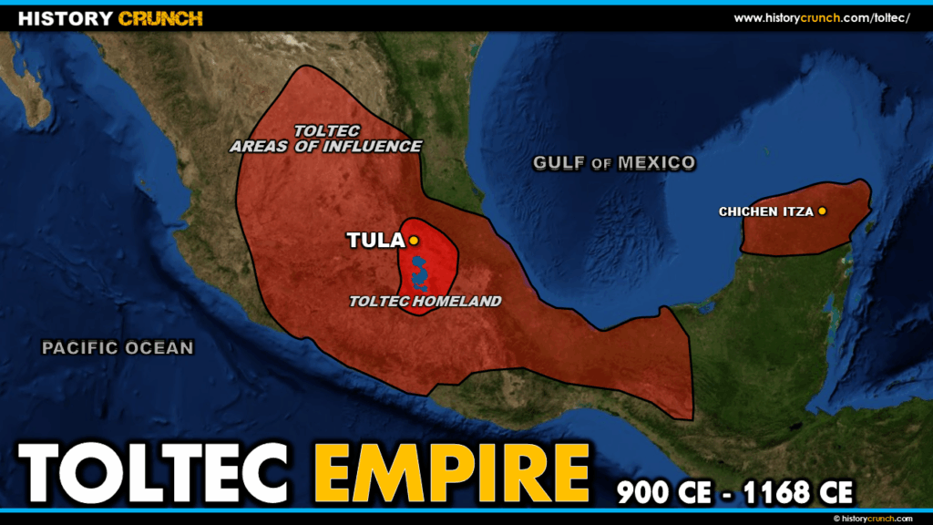
The Toltec were one of the most influential civilizations in Mesoamerican history, flourishing in central Mexico from approximately 900 to 1168 CE. Admired by later civilizations including the Aztec for their art, architecture and craftsmanship, the Toltec left a significant mark on the cultural and religious traditions of Mesoamerica. This map was created by History Crunch to help students visualize the geographic extent of the Toltec Empire and the location of its most important centers, and is based on the History Crunch article titled Toltec.
Map of the Toltec Empire
About This Map
This map of the Toltec Empire was created by the History Crunch team to help students and teachers understand the geographic context of the Toltec civilization in central Mexico. It is designed as a visual learning tool to accompany our full article on the Toltec. Teachers may use it as a classroom display, a geography activity, or a discussion starter about the civilizations that preceded and influenced the Aztec Empire.
What This Map Shows
The map shows the geographic extent of the Toltec civilization in central Mexico. The Toltec heartland was centered in the region northwest of modern Mexico City, in the Mexican state of Hidalgo. This location placed the Toltec at the center of Mesoamerican cultural exchange, allowing their influence to spread widely across the region and reach other major civilizations including the Maya to the south.
The most important location shown on the map is the Toltec capital city of Tula, which was the political and cultural heart of the civilization at its height. At its peak Tula is believed to have had a population of around 60,000 people. The city featured several prominent pyramids, a large central plaza that historians believe could hold festivals attended by as many as 100,000 people, and two Mesoamerican ball courts where the famous Mesoamerican ballgame was played. The most notable structure at Tula is the Pyramid of Quetzalcoatl, named after the prominent Mesoamerican feathered serpent god, which features four large warrior statues on its summit that remain some of the most impressive examples of Toltec craftsmanship.
The map also illustrates the broader Mesoamerican context of the Toltec civilization, showing their relationship to earlier civilizations such as the Olmec and Teotihuacan, as well as their geographic proximity to the later Aztec heartland in the Valley of Mexico. The Aztec considered the Toltec to be their cultural predecessors and the word for Toltec in the Nahuatl language came to mean artisan, reflecting the enormous respect the Aztec held for Toltec craftsmanship and design. Much of Aztec art and architecture was directly modelled on Toltec styles.
Historians believe the Toltec civilization collapsed around the middle of the 12th century, though the reasons for this collapse remain debated. Theories include environmental pressures, internal conflict and warfare in the region. Some historians have also suggested that the Toltec were responsible for attacking and burning the earlier city of Teotihuacan, though this too remains a subject of debate.
How to Use This Map in the Classroom
This map works well as a visual introduction to the Toltec before students read the full article. It can be used as a geography activity asking students to identify the location of Tula and describe the physical environment of central Mexico. Teachers may also use it alongside maps of the Olmec, Teotihuacan and Aztec empires to help students trace the sequence of major Mesoamerican civilizations and understand how each influenced the next. It works particularly well as a discussion prompt asking students to consider why the Aztec admired the Toltec so deeply and what this tells us about how later civilizations understand their own origins.
Related Articles
To learn more about the topics covered in this map, visit the following History Crunch articles: