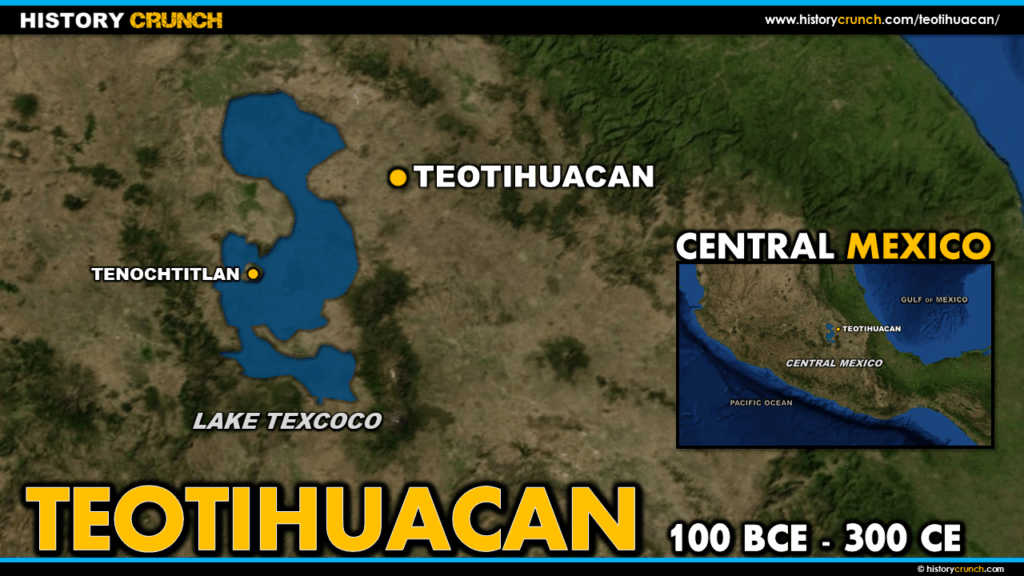
Teotihuacan was one of the largest and most influential cities in the history of the ancient world. Located approximately 50 kilometers northeast of modern Mexico City, it reached its peak around 450 CE with a population estimated at up to 150,000 people and an influence that extended throughout much of Mesoamerica. The Aztec, who discovered the abandoned city centuries later, named it Teotihuacan, a Nahuatl word meaning city of the gods, and believed it to be the place where the gods created the universe. This map was created by History Crunch to help students visualize the geographic location and layout of Teotihuacan, and is based on the History Crunch article titled Teotihuacan.
Map of Teotihuacan
About This Map
This map of Teotihuacan was created by the History Crunch team to help students and teachers understand the geographic context and physical layout of one of the most important cities in Mesoamerican history. It is designed as a visual learning tool to accompany our full article on Teotihuacan. Teachers may use it as a classroom display, a geography activity, or a discussion starter about the great civilizations that preceded the Aztec Empire.
What This Map Shows
The map shows the location of Teotihuacan in the Basin of Central Mexico, situated approximately 50 kilometers northeast of what is today Mexico City. The city was strategically positioned in a fertile valley with access to spring water, agricultural land and nearby obsidian deposits at Pachuca, which were used to manufacture tools and weapons and formed the basis of a wide trading network that extended throughout Mesoamerica.
The map highlights the key structures within the city itself. At the heart of Teotihuacan runs the Avenue of the Dead, a wide ceremonial road approximately 2.4 kilometers long that served as the main axis of the city and connected its most important buildings. The avenue was oriented slightly east of true north and pointed directly toward the sacred peak of Cerro Gordo. Along and at the end of this avenue stand the city’s most iconic structures. The Pyramid of the Sun is the largest structure in Teotihuacan, standing at approximately 66 meters tall with a massive base, and was the tallest structure in the Americas at the time of its construction. The Pyramid of the Moon stands at the northern end of the Avenue of the Dead and is the second largest structure in the city. The Temple of Quetzalcoatl, located at the southern end of the avenue, is richly decorated with stone heads of the feathered serpent deity and is one of the most visually striking buildings at the site.
The map also shows the broader Mesoamerican context of Teotihuacan, illustrating its central position relative to other important civilizations of the region. Teotihuacan’s cultural and religious influence extended far beyond its immediate surroundings, reaching Maya cities as far away as Guatemala and shaping the religious and artistic traditions of many later Mesoamerican civilizations. The Aztec, who encountered the abandoned city centuries after its collapse around 750 CE, revered it so deeply that their ruler Moctezuma made pilgrimages to the site during his reign.
How to Use This Map in the Classroom
This map works well as a visual introduction to Teotihuacan before students read the full article. It can be used as a geography activity asking students to identify the location of the city within Mesoamerica and describe the physical environment of the region. Teachers may also use it alongside maps of the Olmec, Toltec and Aztec empires to help students trace the sequence of major Mesoamerican civilizations and understand the geographic relationships between them. It works particularly well as a discussion prompt asking students to consider why the Aztec held Teotihuacan in such religious reverence even though it had been abandoned for centuries before they arrived.
Related Articles
To learn more about the topics covered in this map, visit the following History Crunch articles: