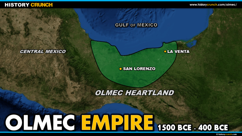
The Olmec were one of the earliest and most significant civilizations in Mesoamerica, flourishing in the tropical lowlands of south-central Mexico from approximately 1500 BCE to 400 BCE. Often referred to by historians as the mother culture of Mesoamerica, the Olmec had a profound influence on later civilizations including the Maya and the Aztec. This map was created by History Crunch to help students visualize the geographic extent of the Olmec Empire and the location of its key centers, and is based on the History Crunch article titled Olmec.
Map of the Olmec Empire
About This Map
This map of the Olmec Empire was created by the History Crunch team to help students and teachers understand the geographic context of one of Mesoamerica’s most important early civilizations. It is designed as a visual learning tool to accompany our full article on the Olmec. Teachers may use it as a classroom display, a geography activity, or a discussion starter about the origins of Mesoamerican civilization.
What This Map Shows
The map shows the geographic extent of the Olmec civilization in the tropical lowlands of south-central Mexico. Today this region corresponds to the modern Mexican states of Veracruz and Tabasco. The Olmec heartland was situated in a fertile lowland environment near rivers, which provided the agricultural resources and transportation routes that allowed the civilization to develop and trade across a wide area of Mesoamerica.
The map highlights the two most important centers of Olmec civilization. San Lorenzo was the earliest major center and served as the heart of Olmec culture during the civilization’s early period. It fell into decline around 900 BCE for reasons that historians do not fully understand, though theories include civil conflict, environmental changes and volcanic activity. La Venta became the dominant Olmec center after San Lorenzo and remained active until the collapse of the Olmec civilization around 400 BCE. Like San Lorenzo, the reasons for the final collapse of La Venta and the broader Olmec civilization remain a subject of debate among historians.
The map also shows the broader region of Mesoamerica in which the Olmec operated, illustrating the trade networks that allowed Olmec cultural practices to spread to other civilizations across the region. The Olmec are credited with being the first Mesoamerican civilization to develop many cultural and religious traditions that were later adopted by the Maya and the Aztec, including human sacrifice, the Mesoamerican ballgame, early writing systems, calendar systems and the concept of zero.
How to Use This Map in the Classroom
This map works well as a visual introduction to the Olmec before students read the full article. It can be used as a geography activity asking students to identify the location of key Olmec centers and describe the physical environment of the region. Teachers may also use it alongside a broader map of Mesoamerica to help students understand the relationship between the Olmec and later civilizations such as the Aztec and Maya. It works particularly well as a discussion prompt asking students to consider why the Olmec chose to settle in the tropical lowlands and how their geographic location shaped their development as a civilization.
H2: Related Articles
To learn more about the topics covered in this map, visit the following History Crunch articles: