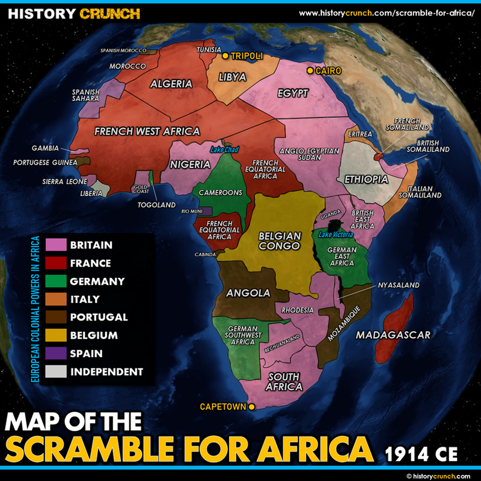
The Scramble for Africa refers to the rapid colonization of almost the entire African continent by the major European powers between approximately 1870 and the outbreak of World War I in 1914. In the space of just a few decades, Britain, France, Germany, Belgium, Italy, Portugal and Spain divided Africa among themselves, drawing borders and establishing colonies with little regard for the existing cultures, societies and boundaries of the African people. By 1914 only two African nations, Ethiopia and Liberia, remained independent. This map was created by History Crunch to help students visualize the geographic extent of the Scramble for Africa and is based on the History Crunch articles on the Scramble for Africa.
Scramble for Africa Map
About This Map
This Scramble for Africa map was created by the History Crunch team to help students and teachers understand the geographic dimensions of the colonization of Africa during the Age of Imperialism. It is designed as a visual learning tool to accompany our full articles on the Scramble for Africa. Teachers may use it as a classroom display, a geography activity, or a discussion starter about how the division of Africa by European powers shaped the continent and the world.
What This Map Shows
The map shows the African continent as it was divided among the European colonial powers by the early 20th century. Each European nation is represented by a different color showing the territory it controlled, allowing students to see at a glance the enormous geographic scale of European colonization.
Britain controlled the largest and most strategically positioned territory across the continent. British colonies stretched from Egypt and Sudan in the north, through East Africa including modern-day Kenya and Uganda, down to South Africa and Rhodesia in the south, as well as large territories in West Africa. France held the largest total area of territory, concentrated primarily across the vast expanse of North and West Africa, including modern-day Algeria, Morocco, Tunisia, Senegal, Mali, Niger, Chad and Madagascar. Portugal held territories on both the west and east coasts of Africa, including modern-day Angola and Mozambique, reflecting its long history as a seafaring power that had established trading posts along African shores since the 15th century. Germany controlled territories in East Africa including modern-day Tanzania, as well as South West Africa and Cameroon. Belgium controlled the enormous territory of the Congo in central Africa, which King Leopold II had first claimed as his personal possession at the Berlin Conference of 1884 and ruled with extraordinary brutality before it was transferred to the Belgian government. Italy controlled territories in North Africa including Libya and in the Horn of Africa including modern-day Somalia and Eritrea. Spain held smaller territories in northwestern Africa and in Equatorial Guinea.
The map also highlights the critical role of the Berlin Conference of 1884. Called by German Chancellor Otto von Bismarck, the conference brought together 14 nations to divide Africa among the European powers and establish boundary lines. African societies were not consulted in this process and the borders drawn at the conference sometimes forced together African groups with histories of conflict and divided groups that shared culture and language. The conference produced approximately 50 African states with irregular borders, many of which still exist today and continue to reflect the arbitrary nature of their colonial origins.
The map shows the two nations that retained independence throughout the Scramble for Africa. Ethiopia successfully resisted Italian attempts at colonization, defeating an Italian military force at the Battle of Adwa in 1896. Liberia, on the west coast of Africa, had been established as a settlement for freed American slaves and maintained its independence with American backing.
How to Use This Map in the Classroom
This map works well as a visual introduction to the Scramble for Africa before students read the full articles. It can be used as a geography activity asking students to identify which European power controlled each region and to calculate what percentage of the continent each nation held. Teachers may also use it as a discussion prompt asking students to consider how the borders drawn at the Berlin Conference of 1884 still affect Africa today, or to examine why European powers were so motivated to claim African territory. It pairs particularly well with the articles on the Berlin Conference, Leopold II and the Congo, the Boer War and the Moroccan Crises.
Related Articles
To learn more about the topics covered in this map, visit the following History Crunch articles: