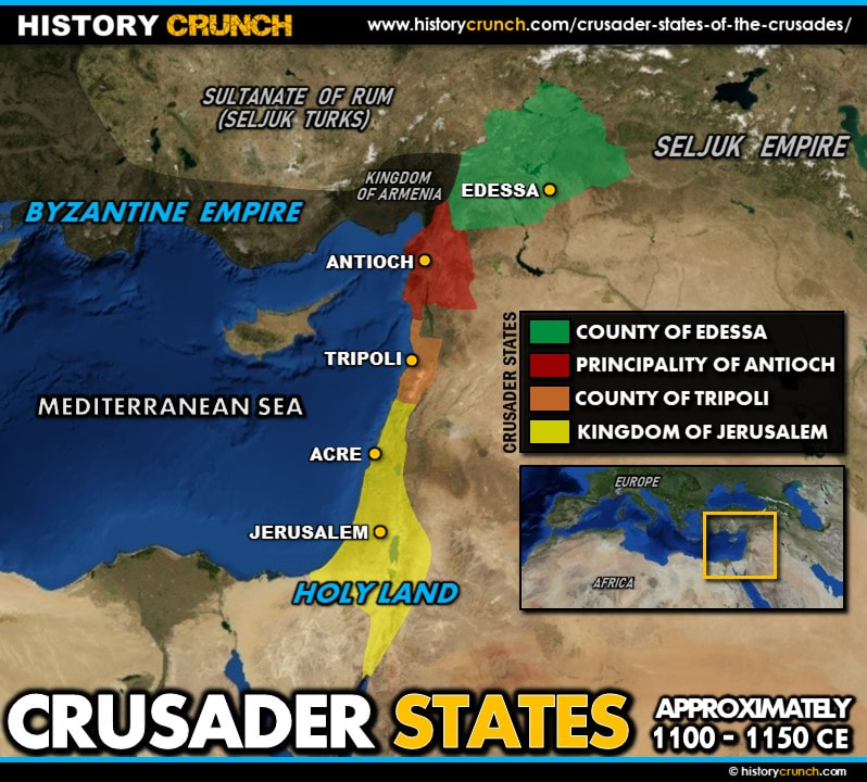
The Crusader States were a series of Christian kingdoms established by European crusaders in the Holy Land and the surrounding region of the eastern Mediterranean following the success of the First Crusade in 1099 CE. There were four main Crusader States: the Kingdom of Jerusalem, the County of Edessa, the Principality of Antioch and the County of Tripoli. These states served as the bases from which crusaders continued their campaigns in the Middle East for the next two centuries and were the central focus of much of the fighting in the Crusades. This map was created by History Crunch to help students visualize the location of the Crusader States and is based on the History Crunch article titled Crusader States of the Crusades.
Crusader States Map
About This Map
This Crusader States map was created by the History Crunch team to help students and teachers understand the geographic location and significance of the Christian kingdoms established in the Holy Land during the Crusades. It is designed as a visual learning tool to accompany our full article on the Crusader States of the Crusades. Teachers may use it as a classroom display, a geography activity, or a discussion starter about why maintaining control of these territories proved so difficult for European crusaders over two centuries.
What This Map Shows
The map shows the geographic location of the four main Crusader States established following the First Crusade along the eastern coast of the Mediterranean Sea. These states were created by the leaders of the First Crusade as they advanced through the region toward Jerusalem between 1096 and 1099 CE. Rather than simply passing through, the crusaders captured and held these territories as permanent Christian kingdoms that could serve as supply bases, staging points and centers of power for future crusading campaigns.
The most important of the four Crusader States was the Kingdom of Jerusalem, which included the holy city of Jerusalem itself. For Christians, Jerusalem was the site of Jesus Christ’s crucifixion and resurrection, making it the most sacred city in the Christian faith. Control of Jerusalem was the central goal of every major crusade, and the Kingdom of Jerusalem changed hands multiple times over the two centuries of the crusading era. It was the capture of Jerusalem by the Muslim leader Saladin in 1187 that triggered the Third Crusade, and regaining the city remained the primary motivation of European crusaders throughout the entire period.
The County of Edessa was the northernmost of the four Crusader States, located in the region of modern-day southeastern Turkey. It was also the most geographically exposed and vulnerable, sitting at the edge of the Crusader presence in the Middle East and frequently coming under attack from the Seljuk Turks to the east. The fall of Edessa to Turkish forces in December of 1144 was the event that triggered the Second Crusade, demonstrating how critical the survival of each Crusader State was to the broader crusading movement.
The Principality of Antioch was located in the region of modern-day southern Turkey and northern Syria. It was an important military and commercial center for the crusaders and served as a key stronghold along the route between Constantinople and Jerusalem. The County of Tripoli was located along the coast of modern-day Lebanon and served as a vital link between Antioch to the north and Jerusalem to the south. Together these four states formed a continuous strip of Christian-held territory along the eastern Mediterranean coastline that was vital to maintaining a crusader presence in the region.
The map also illustrates the broader geographic context of the Crusader States, showing their position in relation to the Byzantine Empire to the north, the Muslim territories to the east and south, and the Mediterranean Sea to the west. Life in the Crusader States was characterized by an ethnically and religiously diverse population that included European settlers, local Christians, Muslims and Jewish people, all living under crusader rule. The states were ultimately lost one by one as Muslim forces grew stronger, with the last major Crusader stronghold, Acre, falling in 1291 CE and bringing the crusading era to a close.
How to Use This Map in the Classroom
This map works well as a visual introduction to the Crusader States before students read the full article. It can be used as a geography activity asking students to locate each of the four Crusader States and identify their geographic relationship to each other and to the surrounding powers. Teachers may also use it as a discussion prompt asking students to consider why maintaining a continuous strip of Christian territory along the eastern Mediterranean coastline was so strategically important to the crusaders, and why the loss of any single state threatened the others. It pairs particularly well with the individual Crusade maps to help students understand how each campaign related to the survival and defense of these states.
Related Articles
To learn more about the topics covered in this map, visit the following History Crunch articles: