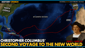
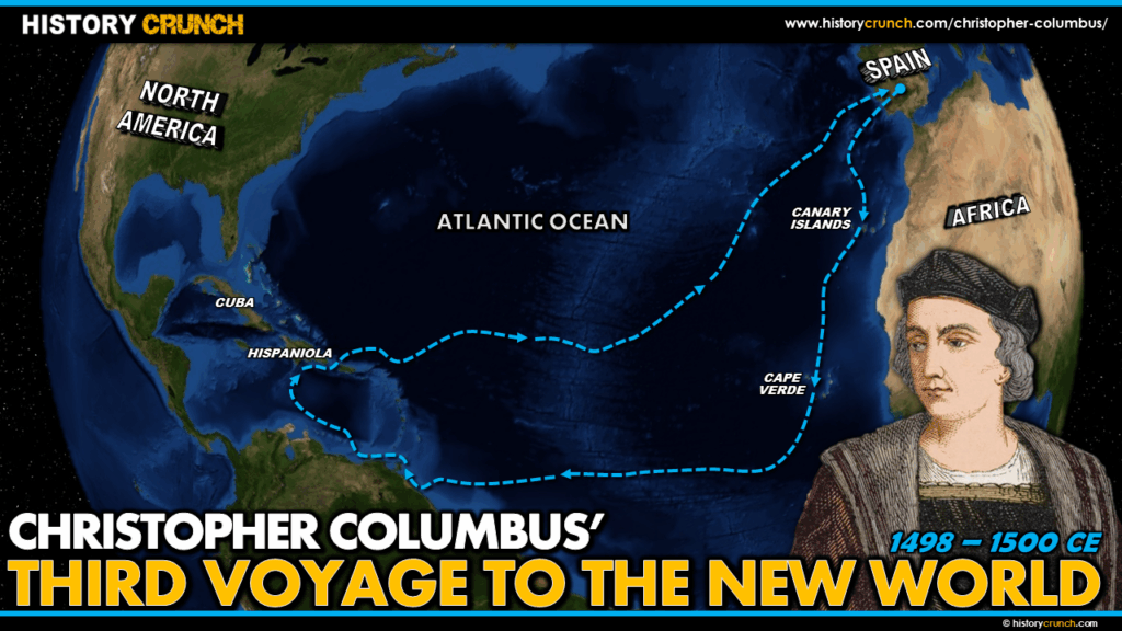
Christopher Columbus’s third voyage to the New World began on May 30th, 1498 and was his most geographically significant in terms of exploration. Taking a more southerly route than his previous two voyages, Columbus arrived at Trinidad and then made contact with the South American mainland at the Paria Peninsula in modern-day Venezuela, becoming the first European to reach the continent of South America. However the voyage also ended in disgrace when Columbus was arrested for his brutal treatment of settlers and indigenous peoples and returned to Spain in chains. This map was created by History Crunch to help students visualize the geographic route of Columbus’s third voyage and is based on the History Crunch article titled Christopher Columbus Third Voyage.
Christopher Columbus Third Voyage to the New World Map
About This Map
This map of Christopher Columbus’s third voyage to the New World was created by the History Crunch team to help students and teachers understand the geographic route and significance of his third voyage, which took him further south than either of his previous journeys. It is designed as a visual learning tool to accompany our full article on Christopher Columbus’s third voyage. Teachers may use it as a classroom display, a geography activity, or a discussion starter about the consequences of Columbus’s rule for indigenous peoples and settlers alike.
What This Map Shows
The map shows the departure of Columbus from Spain on May 30th, 1498 with six ships. Three of the six ships were immediately dispatched to Hispaniola carrying supplies for the settlers remaining there, while Columbus took the remaining three ships on a new and more southerly exploration route across the Atlantic. His intention was to find different islands and locate the Asian mainland, which he continued to believe was nearby.
The map shows the more southerly transatlantic route Columbus followed on this voyage compared to his first two. During the Atlantic crossing his ships became caught in the doldrums, a zone of little or no wind near the equator, and were unable to progress for several days. When the winds returned, Columbus arrived in the New World on July 31st, 1498 at a location considerably further south than he had ever reached before.
The key geographic arrival point shown on the map is the island of Trinidad, located just off the northeastern coast of South America near modern-day Venezuela. Columbus made landfall on Trinidad on August 2nd, named it after the three hills he observed on the island, and restocked his supplies and water. From Trinidad he sailed east and north along the coast and made his most significant discovery of this voyage: first contact with the South American mainland at the Paria Peninsula in northern Venezuela. Columbus observed a large freshwater river flowing into the ocean from the landmass and correctly reasoned that only a continent could produce such a volume of freshwater. He speculated that this landmass might be the location of the Garden of Eden described in the Bible. This was the first time a European had set foot on the South American continent.
The map then shows Columbus’s relatively direct route from the South American coast to Hispaniola, where he arrived on August 19th. There he found the settlers at La Isabela in open revolt against his rule. The situation on the island had deteriorated badly during his absences. The settlers were struggling to survive, frustrated by the lack of gold and angry at Columbus and his brothers for their brutal methods of governance. The Spanish Crown eventually sent Francisco de Bobadilla to investigate, who arrived in 1500, replaced Columbus as Governor and ordered the arrest of Columbus and his two brothers Bartholomew and Diego. All three were returned to Spain in chains in October of 1500.
How to Use This Map in the Classroom
This map works well as a visual companion to the third voyage article and pairs naturally with the first and second voyage maps to help students trace how Columbus’s explorations expanded with each journey. It can be used as a geography activity asking students to identify Trinidad and the Paria Peninsula and locate them relative to the Caribbean islands Columbus had explored on his earlier voyages. Teachers may also use it as a discussion prompt asking students to consider the significance of Columbus reaching the South American mainland and why his continued belief that he had reached Asia meant he failed to understand the importance of what he had actually discovered.
Related Articles
To learn more about the topics covered in this map, visit the following History Crunch articles: