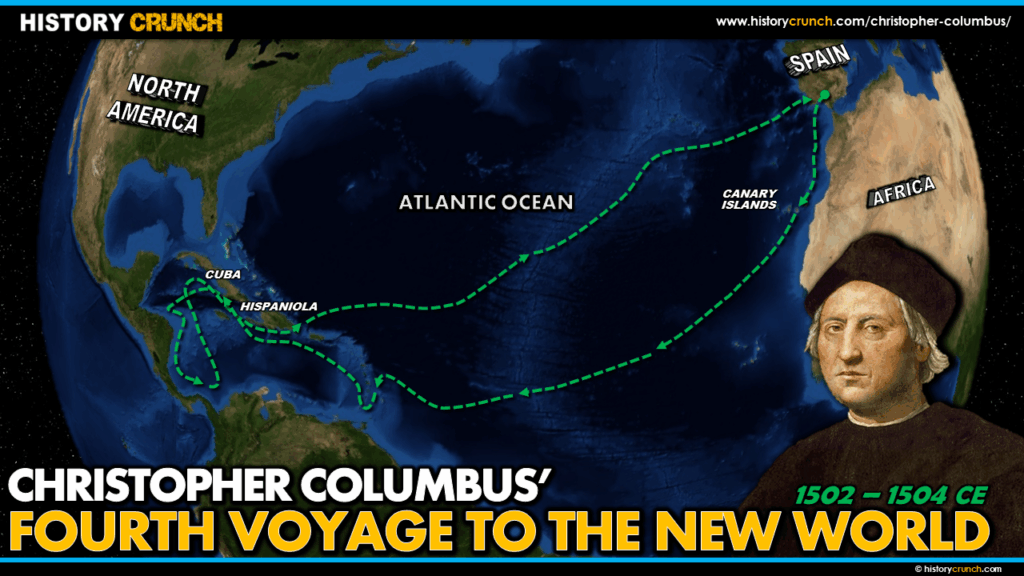
Christopher Columbus’s fourth and final voyage to the New World began on May 11th, 1502 when he left Spain with four ships and approximately 140 men, including his brother Bartholomew and his 13-year-old son Fernando. Still believing he was sailing along the coast of Asia, Columbus sought a passage to the Indian Ocean through what he had discovered. His fourth voyage took him further into Central America than any of his previous journeys, but it ended in disaster with his ships wrecked and his crew stranded on Jamaica for over a year. Columbus returned to Spain in November 1504 and died just two years later. This map was created by History Crunch to help students visualize the geographic route of Columbus’s fourth voyage and is based on the History Crunch article titled Christopher Columbus Fourth Voyage.
Christopher Columbus Fourth Voyage to the New World Map
About This Map
This map of Christopher Columbus’s fourth voyage to the New World was created by the History Crunch team to help students and teachers understand the geographic route of his final and most difficult voyage. It is designed as a visual learning tool to accompany our full article on Christopher Columbus’s fourth voyage. Teachers may use it as a classroom display, a geography activity, or a discussion starter about the challenges and hardships Columbus and his crew faced during this final journey.
What This Map Shows
The map traces Columbus’s fourth voyage from his departure from Spain on May 11th, 1502 through his extensive explorations of Central America and his eventual stranding on Jamaica. After a brief stop in Morocco, Columbus arrived at the island of Hispaniola on June 29th, 1502. This was the island where Spanish colonization had been established during his earlier voyages, and it was now governed by Francisco de Bobadilla, the official who had replaced Columbus as Governor and had him returned to Spain in chains at the end of the third voyage. Bobadilla refused to let Columbus enter the port of Santo Domingo. Columbus anchored nearby and warned the settlement of an approaching hurricane he had observed. Bobadilla ignored the warning, sailed out with nearly 30 ships and lost them all to the storm. Columbus and his fleet survived with little damage.
After the hurricane Columbus sailed to Jamaica and then south to the island of Guanaja off the coast of Honduras. His brother Bartholomew observed local indigenous peoples with a large canoe suggesting larger settlements nearby. Columbus continued south and on August 14th, 1502 he arrived at the mainland of Central America in modern-day Honduras, the first time in any of his four voyages that he made contact with the Central American mainland.
The map shows Columbus’s extended exploration of the Central American coastline over the following months, sailing south along the coasts of Honduras, Nicaragua, Costa Rica and Panama. At Panama in October 1502 Columbus and his crew survived a devastating storm that he later described in vivid detail in his journal. Local indigenous peoples told Columbus there was another ocean on the other side of the land, which he interpreted as confirmation that he was near Asia. In January 1503 he established a garrison at the mouth of the Belen River in Panama, intending to use it as a base for further exploration.
The final section of the map shows the collapse of the fourth voyage. The garrison at the Belen River had to be abandoned after attacks from local indigenous peoples and the ships became heavily damaged and leaking. Columbus abandoned one ship entirely and left Panama on April 16th, 1503 heading for Cuba. Struck by yet another storm, his three remaining ships took on more water and he was forced to run them aground on the northern coast of Jamaica on June 25th, 1503. He and his crew remained stranded there for over a year, surviving with assistance from a local indigenous community. One crew member, Diego Mendez, paddled a canoe to Hispaniola to seek rescue. Columbus famously used his knowledge of an upcoming lunar eclipse on February 29th, 1504 to maintain the support of the local indigenous people during the long wait. Rescue finally arrived on June 29th, 1504 and Columbus returned to Spain on November 7th, 1504, completing his final voyage to the New World.
How to Use This Map in the Classroom
This map works well as a visual companion to the fourth voyage article and pairs naturally with the other three Columbus voyage maps to give students a complete picture of all four journeys. It can be used as a geography activity asking students to trace the route from Hispaniola through the Central American coastline and identify the countries Columbus explored. Teachers may also use it as a discussion prompt asking students to consider why Columbus continued to believe he was in Asia despite the growing evidence to the contrary, and how his four voyages taken together changed the history of the world. It pairs well with the Christopher Columbus infographic and the Columbian Exchange map.
Related Articles
To learn more about the topics covered in this map, visit the following History Crunch articles: