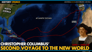
The Columbian Exchange is one of the most significant events in all of world history. Beginning with Christopher Columbus’s second voyage in 1493, it describes the widespread transfer of plants, animals, diseases and people between the Old World of Europe, Africa and Asia and the New World of the Americas. This exchange fundamentally transformed life on both sides of the Atlantic and had lasting consequences for the populations, economies and cultures of the entire world. This map was created by History Crunch to help students visualize the geographic flow of the Columbian Exchange and is based on the History Crunch article titled Columbian Exchange.
Columbian Exchange Map
About This Map
This Columbian Exchange map was created by the History Crunch team to help students and teachers understand the geographic scope and direction of the exchange of plants, animals, diseases and people that occurred between the Old World and the New World during and after the Age of Exploration. It is designed as a visual learning tool to accompany our full article on the Columbian Exchange. Teachers may use it as a classroom display, a geography activity, or a discussion starter about the profound and often devastating consequences of global contact between previously isolated civilizations.
What This Map Shows
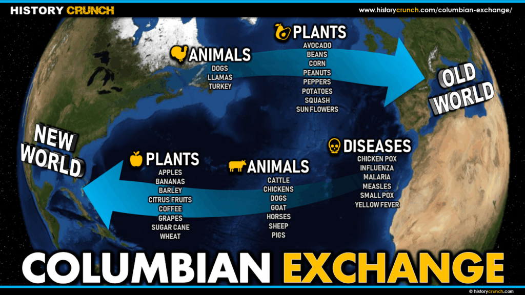
The map shows the Atlantic Ocean as the central geographic feature of the Columbian Exchange, with the Old World (Europe, Africa and Asia) on one side and the New World (the Americas) on the other. Arrows indicate the direction of travel for key goods, animals and diseases, illustrating that the exchange flowed in both directions but with very different consequences for each side.
From the New World to the Old World, European explorers returned home with a remarkable range of plants and food items that transformed the diets and economies of Europe and beyond. Key New World crops included maize (corn), potatoes, tomatoes, beans, squash, chili peppers, peanuts, sunflowers, sweet potatoes, avocado and pineapple. Maize was particularly important because of its adaptability and ability to be dried and stored for long periods. The potato became a staple crop across Europe, particularly in Ireland where dependence on the potato grew so extreme that the failure of the crop in the 1840s caused the devastating Irish Potato Famine. The introduction of these New World foods into the Old World contributed to significant population growth by supporting larger and more varied diets.
From the Old World to the New World, European explorers and settlers brought a wide range of plants, animals and people that transformed the Americas. Christopher Columbus brought seeds, plants and livestock on his second voyage in 1493, including horses, pigs, sheep, cattle, chickens and goats. Before the Columbian Exchange the indigenous peoples of the Americas had no major beasts of burden and all heavy labor was completed by human hands. The introduction of the horse in particular transformed transportation, agriculture and warfare across the Americas.
The most devastating element of the Columbian Exchange shown on the map is the transfer of European diseases to the New World. Indigenous peoples of the Americas had no prior exposure to diseases such as smallpox, influenza, measles, malaria, chicken pox and yellow fever and therefore had no immunity to them. These diseases spread rapidly through indigenous populations with catastrophic results. Some historians have estimated that as many as 90% of the indigenous population of the Americas died from European diseases in the centuries following contact. Smallpox alone decimated entire civilizations, including significantly weakening the Aztec Empire during the Spanish conquest of Tenochtitlan. The spread of disease is widely considered the most consequential and tragic aspect of the Columbian Exchange.
How to Use This Map in the Classroom
This map works well as a visual introduction to the Columbian Exchange before students read the full article. It can be used as a geography activity asking students to categorize the goods flowing in each direction and discuss whether the exchange was balanced or whether one side benefited and the other suffered. Teachers may also use it as a discussion prompt asking students to consider which item transferred in the Columbian Exchange had the greatest impact on the modern world, whether a food crop, an animal or a disease. It pairs particularly well with articles on Christopher Columbus, the Age of Exploration and the Spanish Conquest of the Aztec Empire to help students understand how the Columbian Exchange connected to the broader story of European exploration and colonization.
Related Articles
To learn more about the topics covered in this map, visit the following History Crunch articles: