The Silk Road was one of the earliest and largest trade networks in human history, connecting civilizations across Asia, the Middle East, Africa and Europe for over a thousand years. At its height it stretched more than 4,000 miles from China and Japan in the east to Italy and the Mediterranean in the west. It carried not only goods such as silk, spices and gold but also ideas, religions and diseases that shaped the course of world history. This map was created by History Crunch to help students visualize the key land and sea routes of the Silk Road and is based on the History Crunch article titled Silk Road.
Silk Road Map
About This Map
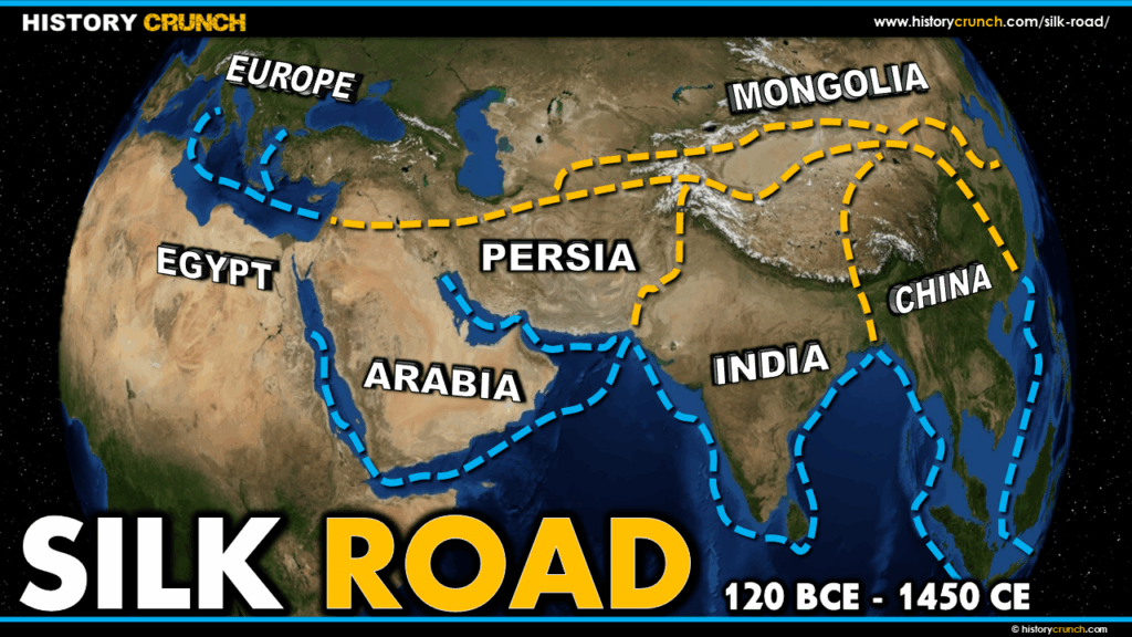
This Silk Road map was created by the History Crunch team to help students and teachers understand the geographic extent of one of the most significant trade networks in the ancient and medieval world. It is designed as a visual learning tool to accompany our full article on the Silk Road. Teachers may use it as a classroom display, a geography activity, or a discussion starter about how trade shaped the development of civilizations across Eurasia.
What This Map Shows
The map shows the major land and sea routes of the Silk Road, which operated from approximately 120 BCE to 1450 CE. The land routes were the most extensive, crossing an extraordinary variety of terrain including deserts, mountain ranges and tropical regions across Central Asia, Persia, the Middle East and into Europe. Most traders did not travel the entire route but instead covered shorter sections, meaning goods changed hands many times before reaching their final destination. Travel along the land routes was typically done in large caravans using camels, which were ideally suited to the long distances and difficult terrain of the overland journey.
The map also shows the important sea routes of the Silk Road, particularly through the Indian Ocean, the Black Sea and the Mediterranean Sea. These maritime routes connected ports in China, India, the Arabian Peninsula and East Africa to the trading cities of the Middle East and eventually to the ports of southern Europe.
Several key regions and civilizations are highlighted on the map. China was the origin of many of the most valuable goods traded along the Silk Road, including silk, paper, glass-based products, spices and food items. Goods flowing in the opposite direction from west to east included grapes, cotton, gold, silver and wool. The civilizations of the Middle East, particularly those in Persia and the Arabian Peninsula, occupied the central position along the Silk Road and served as the primary middlemen of the trade network. This position gave them access to goods from both Asia and Europe, allowed them to accumulate enormous wealth and made the Middle East one of the great centers of learning and knowledge during the Middle Ages.
The map also illustrates the broader historical significance of the Silk Road. Mathematical knowledge, religious beliefs and philosophical ideas traveled along its routes alongside physical goods. The Islamic faith, which originated in the Arabian Peninsula in the 7th century, spread rapidly along the Silk Road through the Middle East, Africa and into parts of Europe. The knowledge flowing through the Middle East also contributed to the intellectual developments that eventually led to the European Renaissance. More tragically, the bubonic plague traveled along Silk Road routes in the 14th century, spreading from Asia into Europe and causing the devastating Black Death that killed millions of people across Eurasia.
How to Use This Map in the Classroom
This map works well as a visual introduction to the Silk Road before students read the full article. It can be used as a geography activity asking students to trace the major land and sea routes and identify the key regions and civilizations that participated in the trade network. Teachers may also use it as a discussion prompt asking students to consider why controlling the middle sections of the Silk Road gave civilizations in the Middle East such economic and cultural advantages. It pairs particularly well with articles on the Black Death, the Middle Ages and the Renaissance to help students understand how connected the routes of the Silk Road were to major events in world history.
Related Articles
To learn more about the topics covered in this map, visit the following History Crunch articles: