The Fifth Crusade took place from 1217 to 1221 CE and was another attempt by European Christians to reclaim Jerusalem from Muslim control. Like the Fourth Crusade before it, the Fifth Crusade targeted Egypt rather than the Holy Land directly, recognizing that Egypt was the center of Muslim power in the region at the time. Despite early successes including the capture of the important port city of Damietta, the campaign ultimately ended in failure and the crusaders were forced to withdraw from Egypt entirely. This map was created by History Crunch to help students visualize the geographic route of the Fifth Crusade and is based on the History Crunch article titled Fifth Crusade.
Fifth Crusade Map

About This Map
This Fifth Crusade map was created by the History Crunch team to help students and teachers understand the geographic dimensions of the Fifth Crusade. It is designed as a visual learning tool to accompany our full article on the Fifth Crusade. Teachers may use it as a classroom display, a geography activity, or a discussion starter about why Egypt became such an important strategic target for European crusaders in the 13th century.
What This Map Shows
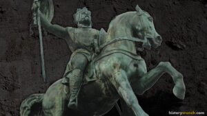
The map shows the broad geographic context of the Fifth Crusade, beginning with the regions of Europe from which the crusaders were drawn. The Fifth Crusade involved participants from many different parts of Europe including France, Hungary, Germany, Portugal and Georgia, making it one of the more geographically diverse crusading forces. It is estimated that as many as 30,000 crusaders participated in the campaign. The crusade is considered to have begun in July of 1217 when Andrew II of Hungary departed for the Holy Land, and he is generally regarded as the leader of the Fifth Crusade. The crusaders traveled across the Mediterranean Sea on a fleet of Venetian ships.
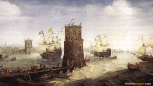
The map highlights Egypt as the primary destination and strategic target of the Fifth Crusade. The crusaders followed the same strategic logic as the planned Fourth Crusade in targeting Egypt first, reasoning that if they could control Egypt they would hold a powerful base from which to eventually reclaim Jerusalem. The most important location on the map is the port city of Damietta, situated on the Nile Delta on the northern coast of Egypt. Damietta was a major commercial and military center and was considered the gateway to Egypt. The crusaders captured Damietta in 1219 after a prolonged siege, which represented the high point of the Fifth Crusade and raised hopes for a decisive victory.
The map also shows the Nile River and the Nile Delta region, which became the theater of the campaign’s most critical and ultimately fatal phase. After capturing Damietta, the crusaders attempted to push further into Egypt toward the city of Cairo. However, the advance stalled badly. The terrain of the Nile Delta with its network of canals and waterways made movement extremely difficult, and the Muslim forces used the flooding of the Nile to trap and cut off the crusader army. The crusaders found themselves surrounded, their supply lines cut and their position increasingly desperate. Faced with no realistic path to victory, the crusader leaders were forced to negotiate a withdrawal. Under the terms of the agreement the crusaders surrendered Damietta and withdrew from Egypt, ending the Fifth Crusade in failure in 1221.
The map illustrates how the enormous geographic distance between western Europe and Egypt, combined with the difficult terrain of the Nile Delta and the military strength of the Egyptian Muslim forces, made the Fifth Crusade an almost impossible undertaking despite the large numbers of crusaders involved.
How to Use This Map in the Classroom
This map works well as a visual introduction to the Fifth Crusade before students read the full article. It can be used as a geography activity asking students to locate Damietta and the Nile Delta and describe the geographic challenges the crusaders faced in trying to advance through Egypt. Teachers may also use it as a discussion prompt asking students to consider why the crusaders chose to target Egypt rather than marching directly to Jerusalem, and whether this strategic choice was sound. It pairs well with the Fourth Crusade map to help students trace the evolving strategic thinking of European crusaders across two campaigns that both targeted Egypt as the key to reclaiming the Holy Land.
Related Articles
To learn more about the topics covered in this map, visit the following History Crunch articles: